CONNECTING COMMUNITIES: SHIFTING THE SILOS

In changing times, the pressure on community organisations to respond and adapt to the needs of families, children and communities is high. With traditional funding streams concurrently being reviewed, many agencies are feeling caught between the high demands of grass roots work with their client group and the need to spend more quality time developing partnerships and planning alternative models to accommodate the changing service system landscape.

The Canopy, a growing multi-focus community organisation based in Lake Macquarie NSW, had existed for 23 years as a small family support agency with 4 staff.  Where agencies had traditionally collaborated with a focus on meeting needs of client groups, they had not collaborated on a broader sector level for the purpose of expanding funding opportunities and improving effective resourcing. Each organisation existed in its own “silo” from this perspective.

The Canopy’s vision was to increase the capacity of the organisation to deliver sustainable projects and programs. This was to be achieved with a strategy that maintained responsiveness to the needs of the region’s families, children and communities. Between 2011 and 2016, the organisation grew its services to include community development and facilities management while increasing the delivery of family services. Operating from 3 venues, effective service delivery remained a priority at all times, but sustainability was equally a consistent consideration.

The key strategies developed for this sustainable growth depended on focussed planning and active participation of all stakeholders including client groups, staff and volunteers, other agencies and government representatives. The traditional competitive silo approach was shifted, replaced with a collaborative and holistic approach. The process relies on trust, transparency, strong leadership, education of staff and a commitment to negotiate in a way which ensures that all organisations involved feel valued and ultimately benefit. More importantly, the vision must be clear at all times.

The rewards for “shifting the silos” are immense. First and foremost, client groups undoubtedly benefit – at the very least by an increase in resources and more streamlined services. Internally, there will be a shift in organisational culture from looking inward for assets, strengths and resources to  looking outward for possible partnerships and collaborations.

In February this year, after securing a partnership with Newcastle City Council, The Canopy has once again increased its service capacity from 3 venues to 8. There are now 20 staff who are proud to work for an innovative, multi-faceted family and community organisation which continues to evolve and adapt in order to meet the needs of their clients during changing times.

Lee-Anne Holmes
Executive Officer
The Canopy Inc.

THE ROLE OF URBAN RESERVES IN PROMOTING SUSTAINABIILITY

THE ROLE OF URBAN RESERVES IN PROMOTING SUSTAINABILITY IN THE PORTLAND, OREGON METROPOLITAN REGION

By Edward J. Sullivan, Adjunct Professor of Urban Studies and Planning
Portland State University

Oregon has developed a unique comprehensive urban growth strategy.  Rural areas are separated from urban areas by an urban growth boundary (UGB) concentrating most urban uses within the boundary and fostering policies to provide urban levels of facilities and services, as wells as varying use intensities for residential, industrial, employment, recreational and commercial uses.  The UGB encompasses existing and anticipated urban uses over a rolling 20-year period.  Expansion of the UGB requires extensive study and public process and is frequently contested.  Those expansions often center on whether adding urban land might be avoided by requiring more intensive use in the existing UGB.

Planning beyond the 20-year timeframe includes “urban reserves,” i.e., those lands to be given first priority for UGB inclusions beyond the initial 20-year UGB horizon.  Designating urban reserves is controversial, because it allows for future inclusion of lands that are suitable for farm or forest use and would otherwise be assigned to a much lower priority for UGB additions.  This is especially apparent in Washington County, a Portland suburb where intense demand for additional lands for the expanding electronics industry onto excellent adjacent farmland.

The criteria for urban reserves are intentionally loosely drawn to provide policy makers with flexibility in determining both need and the precise lands to be designated for long-range urban use. The end result, however, promotes sustainability by requiring public agencies to consider whether additional urban lands are needed and, if so, where those lands should be located.  It is far easier to justify redevelopment and additional intensity of existing urban lands than to face a lengthy and complex challenge to UGB expansion.  Similarly it is far easier to justify expansion when the public services and facilities are available, when full communities are planned and resource lands are protected.  In either event, public agencies must justify both the need for, and extent of, UGB expansion as opposed to greater intensity of use in existing urban areas.

Smart Parking for Smart Cities

Dr Jega Balakrishnan

Traffic congestion caused by vehicle is an alarming problem at a global scale and it has been growing exponentially. Car parking problem is a major contributor and has been, still a major problem with increasing number of vehicles and confined parking spaces in urban cities. Congestion and parking are interrelated since looking for a parking space (called “cruising”) creates additional delays and impairs local circulation. In central areas of large cities cruising may account for 30% of the local circulation as drivers can spend up to 30 minutes on average looking for a parking spot.

Smart city concept is a new approach to redesigning cities and conceiving solutions to recent urban challenges such as traffic congestion, rapid expansion of urban population, increased energy consumption, increased greenhouse gas emission and rising citizens’ expectations. Smart city aims to solve these challenges based upon foundations of good urban planning, economic competitiveness and sustainable practices that use emerging information and communication technologies.

To address the traffic congestion through a smart city approach, eSMART 21 has developed an innovative sensor-based smart parking mobile application. The smart parking application is known as MetroPark which aims to provide citizens with real-time information about available parking spaces in an area. Citizens would be able to pay for their parking through the mobile application without having to feed the traditional parking meters. Prior to time expiry, reminder notifications are sent through the application to enable citizens to purchase additional time for their parking remotely. MetroPark solution would also provide service providers with greater visibility into city’s parking analytics such as parking usage, vacancy, overstay and revenue.

There is considerable evidence to demonstrate that sensor-based application increases parking space turnover and improves retail activity for local business.

For example, a recent SFPark in-ground sensor-based trial conducted in San Francisco revealed that through its technology, the amount of time that pilot areas were too full to find parking spaces deceased by 16% while 51% increment noticed in non-pilot areas. In other words, drivers were able to find vacant parking spaces quickly in sensor-enabled parking areas2.

This improvement reduces vehicle circulation looking for car parks and develops vehicle turnover especially in a busy area like San Francisco. Moreover, reduction in vehicle circulation also reduces carbon emission.

First of its kind MetroPark smart parking application has been specifically designed to increase parking turnover through providing accurate and real-time information based on the sensors to the end users, compliance officers and the service provider. Huge ongoing cost saving is expected through our technology.

Biography

Dr Jega Balakrishnan is the CEO of eSMART 21 – an innovative parking technology solution provider. Dr Balakrishnan has been engaged in the parking industry since 2009. In 2013, Jega has been recognised as a finalist in the Science Excellence Awards, South Australia for developing the state-of-art officer-less SMART ePark technology and for his R&D activities at the University of Adelaide. The SMART ePark technology is designed to improve vehicle turnover, improve operational efficiency, increase parking revenue and improve car parks security without relying on compliance officers. Jega is also currently leading the Australia’s first Smart and Connected ‘Cisco Lighthouse City’ smart parking mobile payment application project with the Adelaide City Council.

Contact details:
Dr Jega Balakrishnan
Director and CEO – eSMART 21 Pty Ltd
T: +61 8 8313 0517
M: +61 425 933 338
E: [email protected]


Land of opportunity – accommodating population and social diversity from the ashes of manufacturing

Preston is a typical Melbourne working class suburb characterised by industrial properties along key routes with surrounding ¼ acre worker housing.

The recent decline in Australian manufacturing has resulted in many sites becoming vacant and jobs going out of these areas.  In many cases these vacated sites are large enough to accommodate significant residential, commercial and civic infrastructure and therefore generate local employment.

They also present a great opportunity for exemplary urban design outcomes due to the sheer scale.

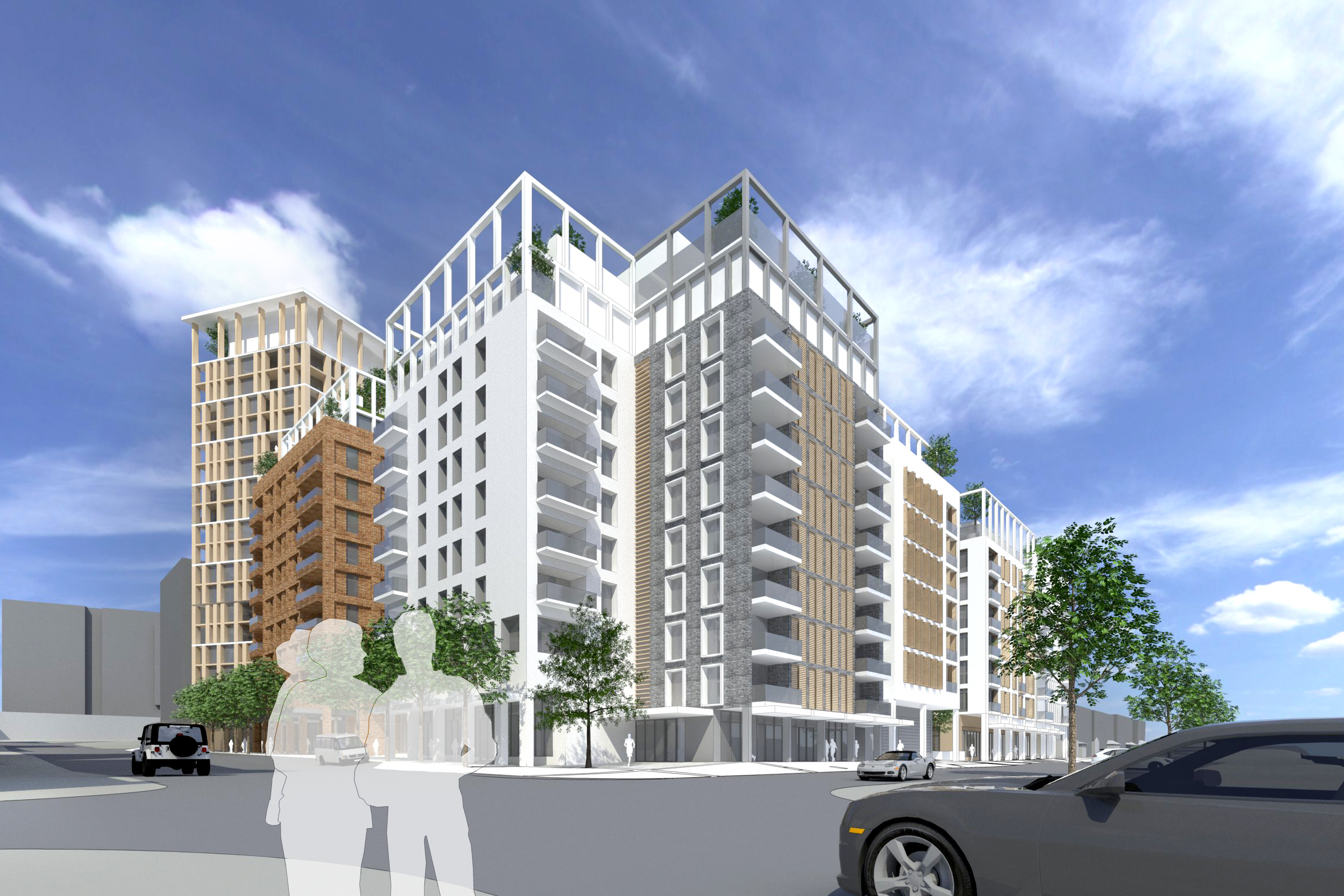
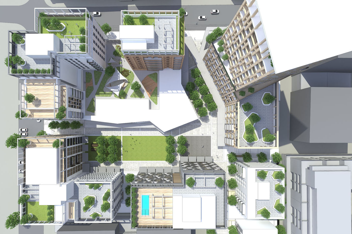
Oakover Square is such a property.  This proposal is an example of industrial land being successfully knitted back into its suburban context.  It provides an urban village development model based on a series of “key moves” designed to establish meaningful community connections and a high level of liveability, as follows:

  1. Net positive urban outcome – protected public and private amenity, favourable aspect to and from buildings, an architecture that is highly expressive
  2. Contribution to public open space – an urban square at the heart of the site provides space and amenity for the residents and all the community
  3. Hierarchy of streets – primary streets widened to facilitate access and enhanced through landscaping, the green streets and pocket parks create attractive amenity for residents
  4. Enable modes of public transport – a highly porous pedestrian and bicycle network and inter-modal public transport exchange
  5. Vertical green amenity – ground level community and commercial uses integrated with landscape, first floor child care with open play areas and upper level green terraces accessible to residents.
  6. Encourage Social diversity – a mix of housing types, diverse employment opportunities and a collection of buildings with individual character and identity.

The development convenes around a central public square with a grid of internal streets and lanes which are generated from the surrounding context.  Combined with pocket parks these provide a series of gathering places of different scales and levels of intimacy.

A multi-generational village is created through offering a variety of residential options.  Localised retail and soho suites activate the ground plane and connect with the existing grain.  Vertical layering enriches the experience through multi-level greenery, providing secluded havens, enhanced amenity and visual stimulation.

The idea is relaxed enough to allow each of the pieces its own character and an equivalence of urban space-making between buildings and open areas.

While subject to statutory height limits, the investment of social capital such as child care, aged care and affordable housing, combined with the contribution of public open space, provides community benefits which justify a significant uplift in scale.

The consequential additional height provides the necessary critical mass of residential infrastructure to support the financial, operational and commercial feasibility of the place.

The overall impression is a sophisticated approach to urban place-making with the feel of a highly energised and individual local living hub.  This is type of outcome we need to address the increased demand for housing in these inner city suburbs.

Murray Brassington
Partner – Commercial
BALDASSO CORTESE


Three way communication creates place making results

Two years ago, the town of Nambour on the Sunshine Coast was a little lost. It had great ‘bones’ but the surface was looking a little tired. The place was a bit … well, directionless. Fast forward one year, and the local council adopted the Nambour Activation Plan. Unlike many plans, the Activation Plan does not prescribe what must happen, when and at what cost. Rather, it is an ‘enabler’ – providing the webbing and stimulation for locals to define the types of projects and place Nambour wants to be.

Fast forward another year to the present, and the catchphrase ‘a thriving and extraordinary place to live, work and play’ is beginning to ring true, as many of the actions proposed are either completed or underway. The key is the three way partnership between the community, council, and the Nambour Alliance (which represents the businesses of the area) that has existed since the first proposal to ‘do something about Nambour’. This collaboration has allowed open discussions on how best to re-invigorate the town through both short term and long term place making activities.

With all three groups working together, the town has progressed four ‘big’ key strategic projects that were identified through consultation. Council will soon finalise design plans to re-invent the local aquatic facilities, and provide better access to the local creek and surrounding open space.

Over $600,000 has been raised through grants and donations to restore and re-introduce the heritage cane train to the centre of town. When operational, it will be one of the few heritage trams in Australia regularly transporting people.

Council funding allocations have been brought forward to complete a detailed design to expand the facilities of the iconic showgrounds. Blank walls are sporting funky artworks instead of graffiti, buskers and food trucks are popping up, and local music is being supported thanks to a small number of venues. With common support from the community, council and the Nambour Alliance, Nambour is rediscovering its soul.

For further information on the place making activities in Nambour, go to the Nambour Activation Plan site.

Paul McKinlay | Social Policy Officer
Open Space and Social Policy Team | Environment & Sustainability Policy
Planning and Environment Department | Sunshine Coast Council
Website: www.sunshinecoast.qld.gov.au